Indo-Gangetic Basin
Overview of Initiative
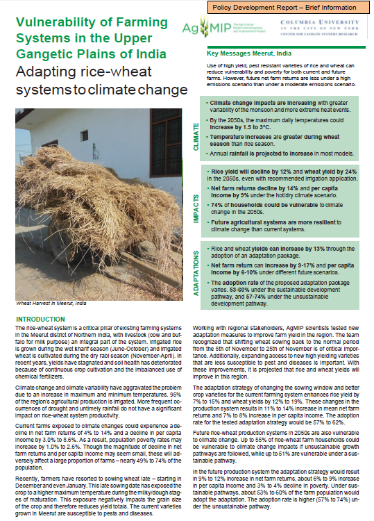
The Indo-Gangetic Basin is located across the northeastern border of India and includes portions of Bangladesh, Nepal, and Pakistan. The region has seen increased variability in its monsoonal season along with more frequent extreme weather phenomena such as heat waves and intense rainfall. These anomalies can have major impacts on the agriculture industry in this part of the world. Assessing how climate change may play a role in continued seasonal variability going forward is important for future planning.
Phase 2 (2015-2017) applied simulation tools within major farming system ecologies of the central and eastern portions of the region. Through this, linkages between agricultural productivity and impending climate change were better understood. By engaging with stakeholders within the Indo-Gangetic Basin (IBG) region, the Team more accurately understood these linkages and their connections to livelihoods. From here, management and policy strategies were listed out to determine the effective responses to the region’s changing conditions.
The IGB Project expanded stakeholder dialogue during Phase 2. This resulted in meaningful and accurate integrated assessments. At the Meerut and Karnal sites, Phase 2 incorporated the simulation of more crops, while also integrating a livestock component. This integration provided a more in-depth assessment of these locations.
Throughout Phase 2, the IGB team developed stronger research capabilities and connections. In improving the breadth of crops and models used in the assessment, research capabilities of researchers across South Asia were strengthened.
The Team achieved its goals through various methodologies. The Team continued its focus on the economic models, farming systems, and development of RAPs within the region. They also evaluated historical and future climate analysis along with delivering harmonized data. In addition, the team ensured results and research were co-developed with stakeholders.
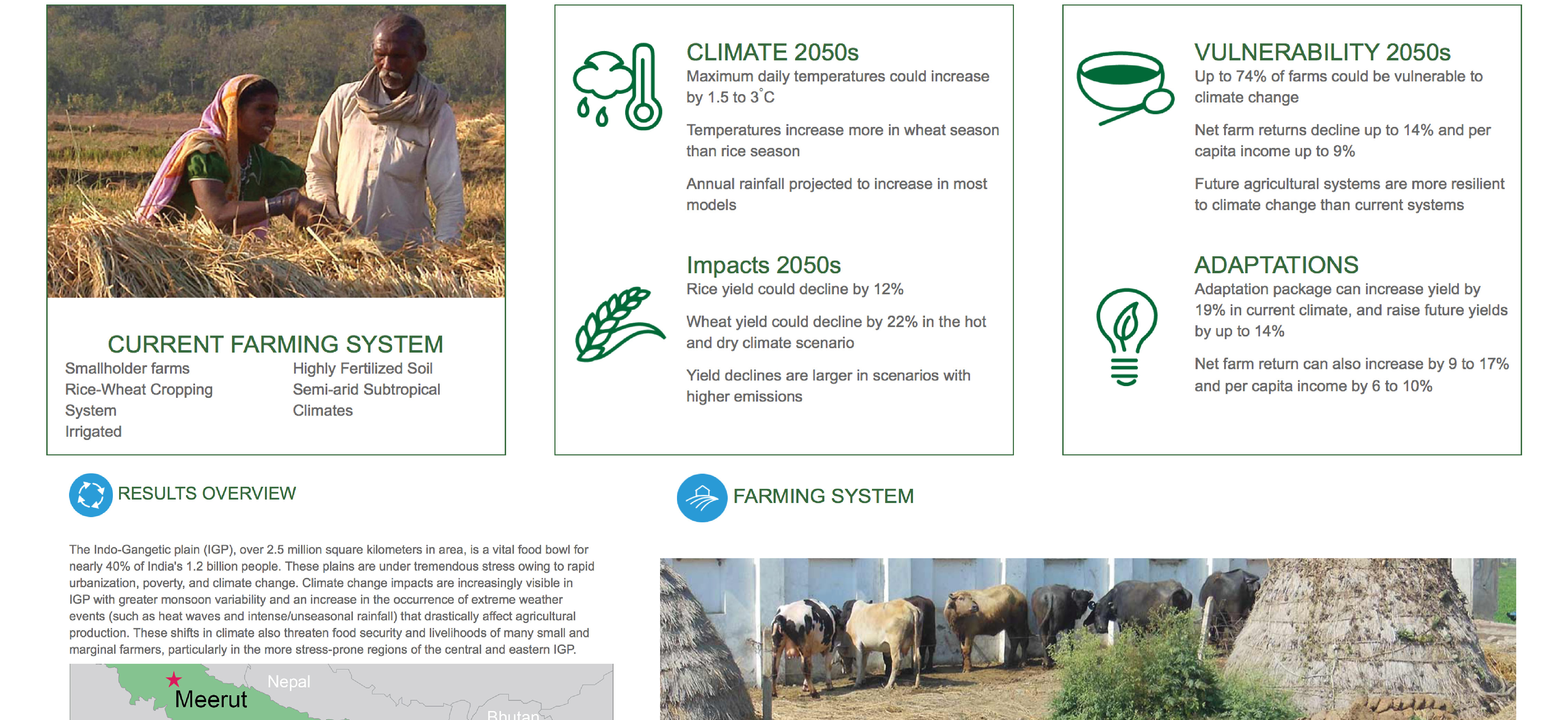
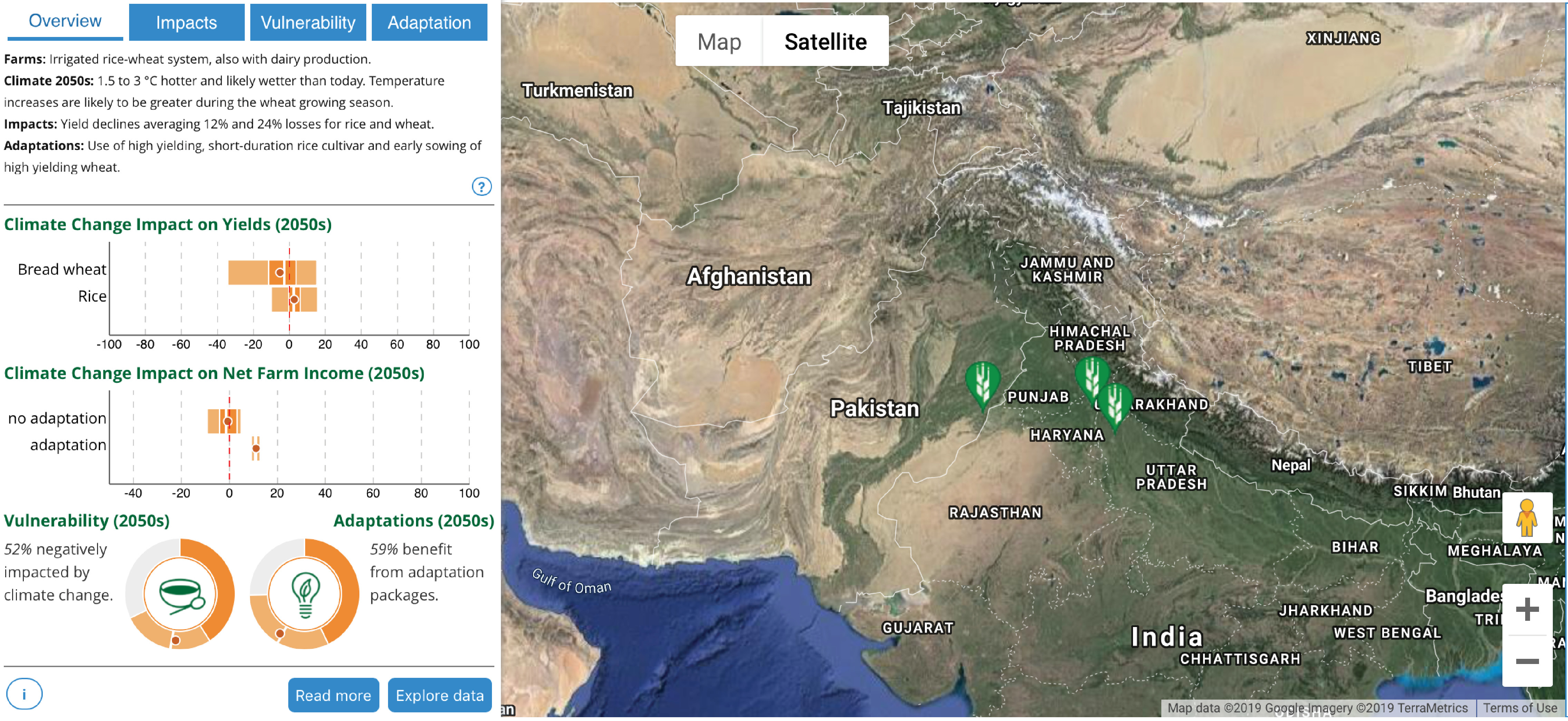
Impacts Explorer – Meerut, India
Vulnerability of rice-wheat small farm households
Indo-Gangetic Basin Team members
Nataraja Subash: Lead PI
Harbir Singh: Lead Economist
Gokul Paudel: Economist
Mohar Singh Meena: Stakeholder liaison
Sohan Vir Singh: Livestock team
Balwinder Singh: Crop Modeling
Abeed Hussain Chowdhury: Geo-spatial analysis; Crop modeling
Rajendra Doraj: Crop Modeling
Dinesh Tapa: Economist; Nepal Stakeholder liaison
Kamrul Hassan: Economist
Sohela Aktar: Crop modeler
Gulam Hussain: Crop modeler; Bangladesh stakeholder liaison
Research Summary:
MEERUT, INDIA
Crops: Rice and Wheat
Models: DSSAT, APSIM, LivSim, and InfoCrop
Farm System: Rice-wheat, livestock
Economic Strata: Single strata (small farms)
Possible Adaptation: Rice – Short duration varieties; Wheat – 10-day advancement of wheat sowing; Short duration varieties – with less water requirement
KARNAL, INDIA
Crops: Rice and wheat
Models: DSSAT, APSIM, LivSim, and InfoCrop
Farm System: Rice-wheat, livestock
Economic Strata: Two strata: with and without livestock
Possible Adaptation: Rice – Short-duration, high-yielding varieties; Wheat – 10-day advancement of wheat sowing
FAIZABAD, INDIA
Crops: Rice and wheat
Models: DSSAT, APSIM and InfoCrop
Farm System: Rice-wheat
Economic Strata: Single strata (small farms)
Possible Adaptation: Sustainable use of water – proper utilization of groundwater to increase productivity; Use of short duration/ high yielding varieties; Balanced/ recommended use of fertilizer
SAMASTIPUR, INDIA
Crops: Rice and wheat
Models: DSSAT, APSIM and InfoCrop
Farm System: Rice-wheat
Possible Adaptation: Sustainable use of water – proper utilization of groundwater to increase productivity; Use of short duration/ hig yielding varieties; Balanced/ recommended use of fertilizer
BANKE-NEPALGANJ, INDIA
Crops: Rice
Models: DSSAT and APSIM
Farm System: Rice-wheat
Economic Strata: Single strata (small farms)
Possible Adaptation: Advance wheat crop sowing by 20 days
DINAJPUR, INDIA
Location: Dinajpur, Bangladesh
Crops: Rice and wheat
Models: DSSAT and APSIM
Farm System: Rice-wheat
Economic Strata: Single strata (small farms)
Possible Adaptation: Wheat: Increase irrigation amount by 50mm
KEY PARTICIPATING INSTITUTIONS
Indian Council of Agricultural Research – Indian Institute of Farming (ICAR-IIFSR)
The Bangladesh Agricultural Research Council
The Nepal Agricultural Research Council
The International Maize and Wheat Improvement Center (CIMMYT)
Indian Council of Agricultural Research – National Dairy Research Institute
Indian Council of Agricultural Research – Agricultural Technology Application Research Institute, Jodhpur